This guide is written for regular travelers—often in their 40s and beyond—who want to experience the best classic Dolomites views on well‑marked day hikes and panoramic viewpoints, without technical climbing or via ferrata gear.
If you want mountain scenery that feels almost unreal but do not want to spend your vacation gasping up steep switchbacks, the Italian Dolomites are perfect. This list of hikes in the Dolomites can still give you towering limestone walls, emerald lakes, wide alpine meadows, and even those classic rifugios. The routes I chose are scenic enough to justify the trip, yet manageable so you can enjoy them without turning the whole outing into an endurance event.
In the sections below, you’ll find a curated selection of the best hikes in the Dolomites arranged from the most demanding to the easiest. For each one, I share key stats at a glance, how to get there, what the trail actually feels like, and honest pros and cons so you can choose the routes that match your energy level, comfort with crowds and travel style.
Overview of the Best Dolomites Hikes in This Guide
Here’s a quick look at the hikes and walks covered in this guide so you can see which ones fit your plans at a glance:
| Tre Cime di Lavaredo | The classic Dolomites circuit around three towering peaks with huge views almost the entire way. |
| Seceda Ridgeline Walks | Dramatic cliff‑edge panorama above Val Gardena, reached by cable car with options from short strolls to longer hikes. |
| Val Falcina Nature Trail | Quiet forest loop with waterfalls and lush greenery, a peaceful alternative to the blockbuster hikes. |
| Cinque Torri Loop | Short hike among rock towers and World War I trenches, combining history and scenery in one compact circuit. |
| Lago di Braies Loop | Gentle lakeside trail around a turquoise alpine lake, perfect for a low‑effort “wow” day. |
| Lago di Misurina lakeside walk | Very easy, relaxed lap around a pretty lake with mountain views, ideal for a recovery or “half‑day” outing. |
Map of the Best Hikes in the Italian Dolomites
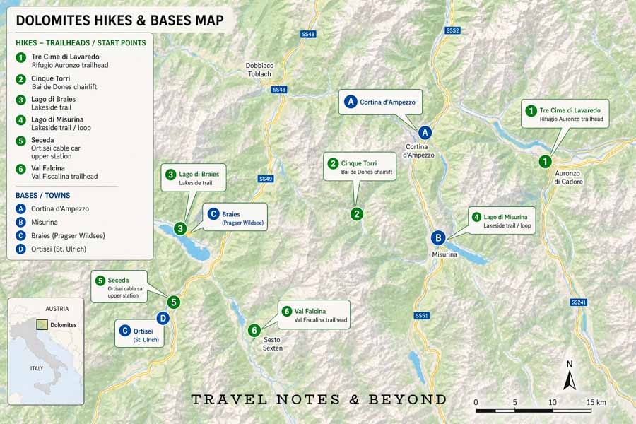
NOTE: This map shows where each hike in this guide starts, along with nearby bases like Cortina d’Ampezzo, Misurina, Braies and Ortisei. Use it to see which hikes cluster together and how far they are from where you’re staying, so you can combine a couple of shorter walks in one day or spread out the more demanding hikes. I’ve marked key cable car stations and parking areas to make the logistics easier to visualize before you arrive.
How to choose the right Dolomites hike for you
With so many beautiful options, it’s useful to narrow things down based on where you’re staying, how much you want to walk and what kind of scenery you care about most.
By where you’re staying
- Cortina d’Ampezzo / Misurina – Best for Tre Cime di Lavaredo, Cinque Torri and Lago di Misurina. You can easily make day trips to Tre Cime and Cinque Torri from Cortina, while Misurina puts you closer to Tre Cime and offers a very easy lakeside walk.
- Alta Pusteria (Dobbiaco / Villabassa / Braies area) – Ideal for Lago di Braies and within reach of Tre Cime. Staying nearby gives you the best chance of early starts to beat both crowds and parking restrictions.
- Val Gardena (Ortisei / Santa Cristina / Selva) – Perfect for Seceda, with excellent lift access and plenty of hiking‑friendly infrastructure.
- More off‑the‑beaten path – Val Falcina works well if you’re exploring outside the busiest hubs and want something quieter and greener.
By effort level (within easy–moderate)
- Most demanding in this list (still non‑technical): Tre Cime di Lavaredo loop, longer Seceda routes.
- Moderate but manageable for most walkers: Val Falcina Nature Trail, Cinque Torri loop.
- Gentle walks with big scenery: Lago di Braies loop, Lago di Misurina lakeside walk.
By what you care about most
- Want that classic “Dolomites postcard” ridge view? Choose Seceda.
- Prefer lakes and reflections? Start with Lago di Braies, then add Lago di Misurina.
- Enjoy history as much as scenery? Cinque Torri combines both in a compact, rewarding loop.
- Want something quieter and greener? Val Falcina gives you a more relaxed, local feel than the blockbuster hikes.

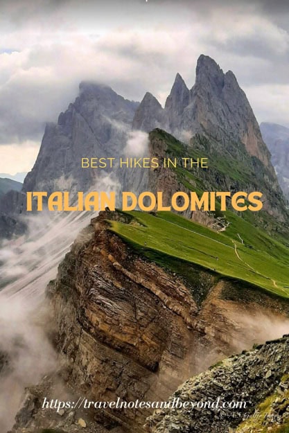
THE BEST HIKES IN THE ITALIAN DOLOMITES
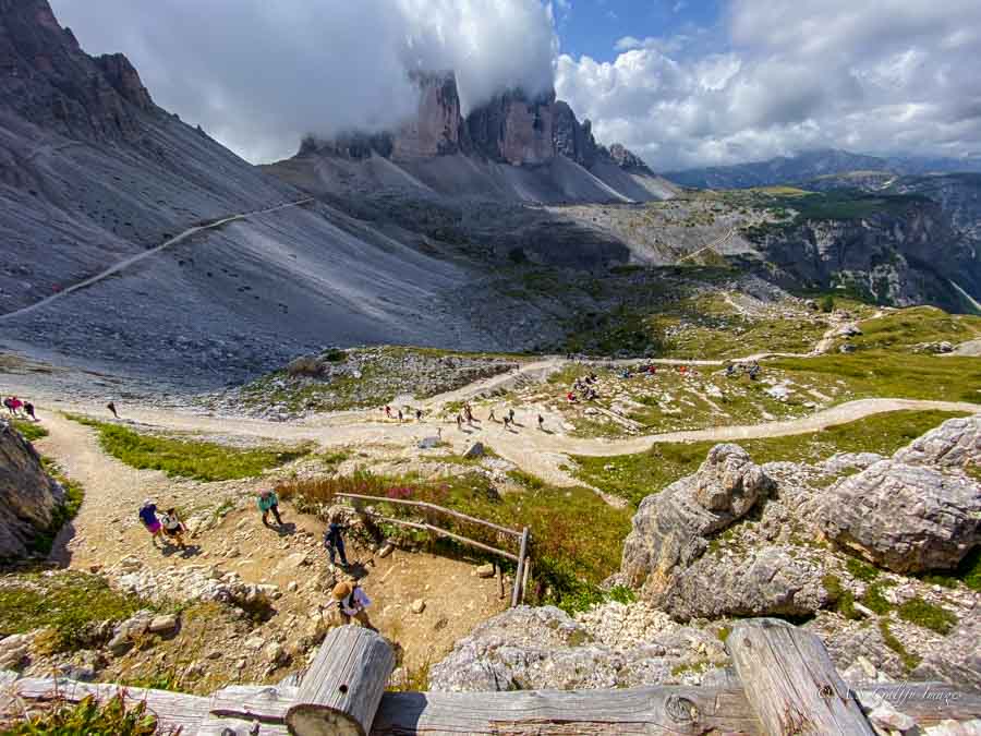
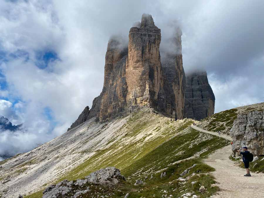
1. Tre Cime di Lavaredo Loop
At a Glance
- Distance: ~9–10 km (depending on variations)
- Elevation gain: roughly 350–400 m
- Time: about 3.5–5 hours, depending on pace and photo stops
- Difficulty: Easy–Moderate (non‑technical but with sustained walking and some steeper sections)
- Trail type: Loop
- Starting point: Rifugio Auronzo car park
- Access: Toll road from Lago di Misurina to Rifugio Auronzo; limited parking, bus access in high season possible
- Best months: Late June to late September (road access and snow conditions dependent)
If you only do one hike in the Dolomites, this is probably the one to choose. Tre Cime di Lavaredo is iconic for a reason. The three giant peaks that dominate the skyline and the trail will be in your view almost the entire way. The rock formations feel big and dramatic from the moment you step out of the car. And walking the entire loop is still very doable for most reasonably fit walkers.
How to Get There
The hike starts at Rifugio Auronzo, which you can reach by a toll road that climbs high into the mountains. That road is the main logistical hurdle, not the hike itself. During the peak season, parking may be restricted or require advance reservation. And even when reservations are not required, you don’t want to show up late and hope for the best. Early morning is the sweet spot here. Arriving shortly after sunrise gives you cooler temperatures, softer light, and a much better chance of finding a parking place.
How Long Does the Hike Take
The classic loop takes about 3.5 to 5 hours, depending on how often you stop and whether you walk the full circuit or take a slightly shorter variation. The trail itself is not technically difficult. However, it does include some uneven sections and uphill stretches which are a little more difficult. That said, it is still one of the most accessible ways to experience the Dolomites at their most dramatic points. At any rate, this hike is the most demanding on this list.
What Is the Best Route
For the best route, go counterclockwise from Rifugio Auronzo. This direction is popular because it gets you into the scenery quickly. It also makes the rest of the hike feel like a smooth progression of increasingly impressive viewpoints. You will pass classic photo stops and broad views toward the Cadini di Misurina area. Along the way you’ll come across several rifugios where you can stop for coffee, a snack, or lunch.
Because Tre Cime is so popular, the trail tends to get very crowded as the day goes on. If you prefer a quieter feel, start very early and keep moving after your first photo stops rather than lingering near the trailhead viewpoints. If your time or energy is limited, you can also walk an out‑and‑back segment from Rifugio Auronzo to one or two viewpoints and then return the way you came.
Pros
- Some of the most iconic scenery in the Dolomites almost all the way around the loop.
- Well‑marked path with several rifugi for food, bathrooms and weather shelter.
- Flexible: you can walk the full circuit or cut it shorter if needed.
Cons
- Very popular and often crowded in peak summer; parking and traffic can be stressful.
- Toll road and parking fees make it a more expensive outing.
- Some sections feel exposed if you’re uncomfortable with drop‑offs, even though no climbing or scrambling is involved.
2. Seceda Ridgeline Walks
At a Glance
- Distance: ~1.3 km for the short ridge viewpoint loop; up to 12 km for longer routes
- Elevation gain: Minimal for the short loop; significantly more for the long descent routes
- Time: 30–45 minutes for the ridge loop; 5–7 hours for full extended hikes
- Difficulty: Easy (short ridge loop) to Moderate (longer plateau and descent routes)
- Trail type: Network of marked paths, out‑and‑back or various loops
- Starting point: Seceda cable car upper station above Ortisei
- Access: Elevator + cable car from Ortisei in Val Gardena; no direct car access to the trailhead
- Best months: Late June to late September (check lift schedule)
Seceda is one of the most popular hikes in the Dolomites whose landscape is absolutely breathtaking! And the good news is that you do not need to be doing a hardcore mountain trek to appreciate it. While the area can be approached in several ways, the easiest visit usually involves the lift system and then a scenic walk once you are up high. That gives you the big views without making you earn every meter of elevation on foot.
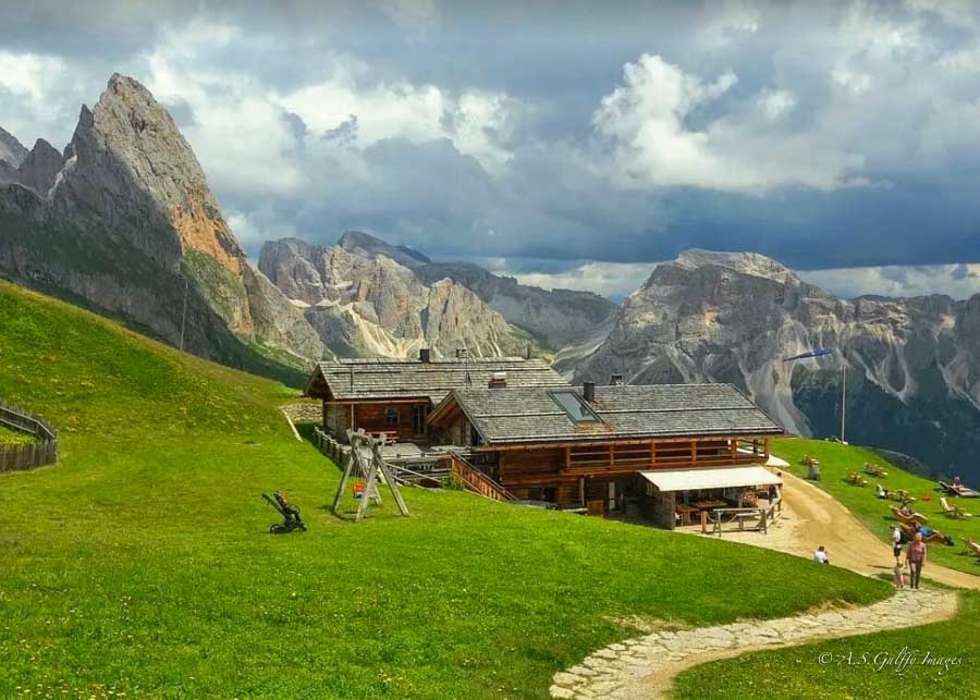
If you want a hike that feels scenic and slightly more adventurous without becoming difficult, Seceda is a strong option. It is especially good for people who care about photography or simply want to stand in one of the most recognizable places in the Dolomites without committing to a huge hiking day. The views here do most of the work for you.
How to Get to the Trailhead
The easiest way to reach the Seceda trailhead is to take the bus to Ortisei (Urtijëi) in Val Gardena and take the Seceda cable car up to the mountain station. The hike starts from there. From the top station, the main viewpoint and hiking paths are a short walk away. You cannot drive to the actual trailhead.
A second, more demanding option comes from the Col Raiser side near Santa Cristina, which links to Seceda via a network of trails. This route is longer and more strenuous, so if you want the classic ridge views with minimal effort, the Ortisei lift route is by far the better choice.
How is Long is the Hike
The terrain around Seceda is not a single trail so much as a collection of walking options, which is part of what makes it appealing. You can keep it short and simple, or you can turn it into a longer outing if you feel like it. Either way, the payoff is the same: broad alpine panoramas, sweeping grassy slopes, and those unforgettable jagged Dolomite peaks in the distance. It is the kind of place where even a casual walk feels a little cinematic.
The classic ridge viewpoint loop is about 1.3 km (0.8 miles) and takes 30–45 minutes. If however you feel adventurous and have more time, you can do the longer full Seceda hike from the lift station across the plateau and down toward Ortisei. This one is about 12 km (7.6 miles) and takes 5–7 hours with stops.
No matter which option you choose, the payoff is the same: broad alpine panoramas, sweeping grassy slopes and those unforgettable jagged peaks cutting across the sky. Even a short walk here feels cinematic.
Best time to visit
Because access depends on lifts and parking in Ortisei, timing matters. Parking in town garages can fill at busy times, and gondolas can have queues in peak season. Morning is ideal for both crowds and light; the sun tends to illuminate the ridge beautifully and the air is clearer earlier in the day. Always double‑check the lift schedule before planning your hike, as dates and hours can vary by season.
Pros
- Huge “wow‑factor” views for comparatively little effort if you use the lifts.
- Flexible options, from a brief scenic ridge walk to a full‑day hike across the plateau.
- Excellent for photography and for experiencing that archetypal Dolomites landscape.
Cons
- Lift tickets and parking add to the cost of the outing.
- The immediate ridge viewpoint can be crowded in peak season and around sunset.
- Longer routes require solid stamina; once you start descending, turning back is not always appealing.
3. Cinque Torri Loop
At a Glance
- Distance: ~2–2.5 km loop (depending on path)
- Elevation gain: About 120 m
- Time: Roughly 1.5–2.5 hours with photo and history stops
- Difficulty: Easy
- Trail type: Loop
- Starting point: Rifugio Scoiattoli / upper chairlift station
- Access: Seggiovia Cinque Torri chairlift from Baita Bai de Dones parking on SS48, or by hiking up from the road
- Best months: June to early October (chairlift operating season)
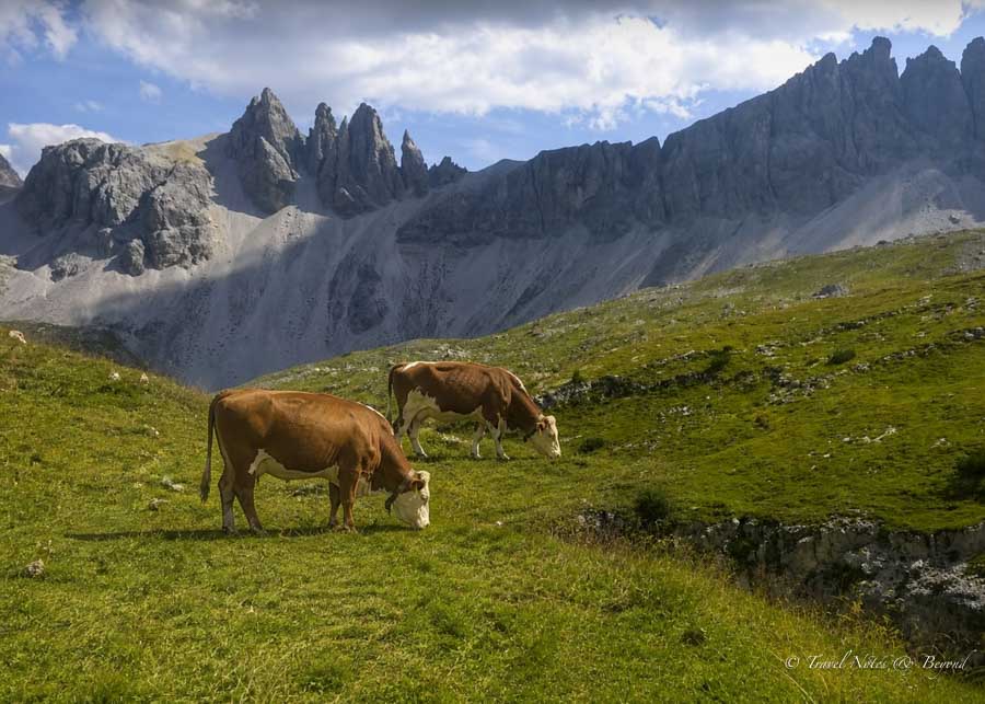
Cinque Torri loop is one of the best ways to immerse yourself in classic Dolomites scenery without committing to a long or strenuous hike. The short loop circles around a group of dramatic limestone towers rising out of alpine meadows, with wide views toward peaks like Tofane and Nuvolau. On top of that, the area doubles as an open‑air World War I museum, with trenches and bunkers hidden among the rocks.
The trail goes around the dramatic limestone towers rising sharply from alpine meadows, offering some of the region’s most accessible and photogenic scenery. It’s worth visiting for its jaw-dropping panoramic views of peaks like Tofane and Nuvolau, combined with well-preserved World War I sites including bunkers and trenches hidden among the rocks.
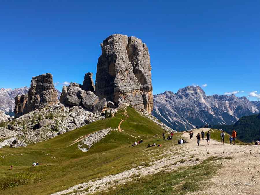
In addition to its natural beauty, the Cinque Torri hike is also a WWI open-air museum with informational panels and outdoor exhibits that make your hike even more interesting.
How to Get to the Trailhead
The easiest way to reach Cinque Torri is via the Seggiovia Cinque Torri chairlift from Baita Bai de Dones parking lot. The chairlift, which operates June to early October, is located just off SS48 near Passo Falzarego (about 13 km from Cortina d’Ampezzo). Parking is free at the large lot by the base station (46.512°N, 12.015°E), though it fills quickly in peak season. To make sure you can get a spot, arrive early or use the bus from Cortina.
How Long Does the Hike Take
The easy loop that encircles the towers is about 2-2.5 km long (depending on the trail you choose) and has minimal elevation gain (120m). It takes roughly 1.5-2.5 hrs and it suits all fitness levels, making it ideal for families, photographers, or those short on time seeking quintessential Dolomite magic without extreme effort.
Best Route
For the best experience, my recommendation is to go clockwise, starting from Refugio Scociattoli towards the Sentiero delle Trincee (path of the trenches). This trail avoids the main climb and offers a relatively flat, scenic walk around the towers, including WWI bunkers. This loop is the easiest and most popular way to explore Cinque Torri.
Pros
- Short, accessible loop with classic Dolomites rock formations and big views.
- Fascinating WWI history built into the landscape through trenches and bunkers.
- Easy to combine with other nearby sights or hikes in the Cortina area on the same day.
Cons
- Chairlift schedule limits when you can visit; you’ll need to check dates and hours.
- Can still get busy in high season given its ease and proximity to Cortina.
- Limited challenge for hikers who prefer longer or more strenuous days.
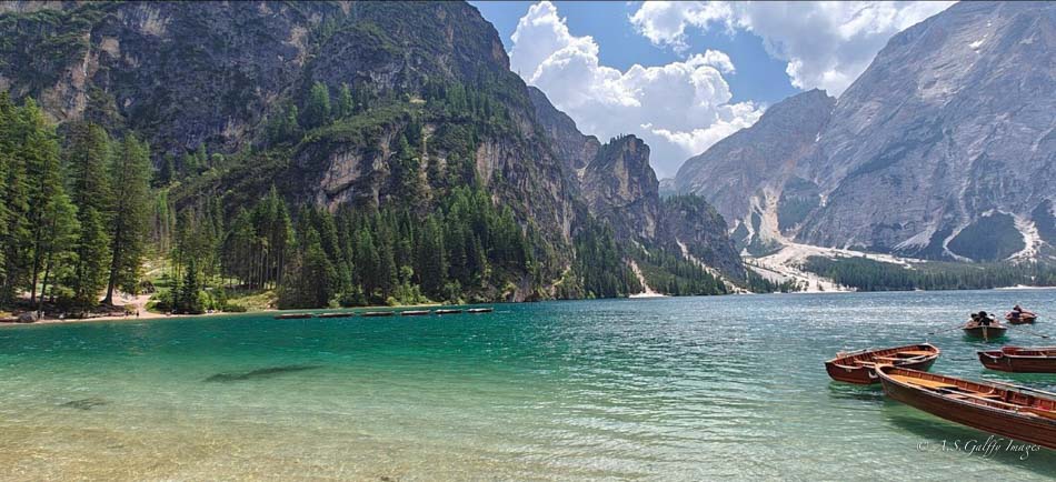
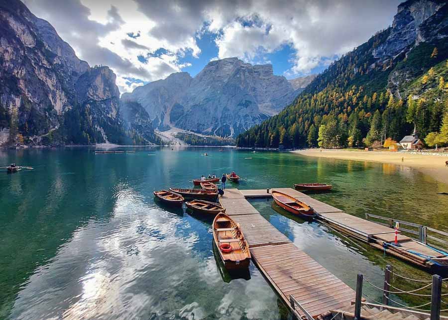
4. Lago di Braies Loop
At a Glance
- Distance: ~3.5–4 km loop
- Elevation gain: Minimal
- Time: About 1.5–2 hours at a relaxed pace
- Difficulty: Easy
- Trail type: Loop
- Starting point: Lakeshore at Lago di Braies
- Access: Road and parking near the lake, plus seasonal bus options; access can be controlled in peak months
- Best months: Late spring to early autumn; access rules vary in high season
Lago di Braies is the kind of place that looks unreal in photos and somehow looks even better in person. The lake sits in a stunning alpine bowl, with steep forested slopes and pale mountain walls rising around it. The hike here is not about effort; it is about atmosphere. If you want something beautiful, relaxed, and very easy to navigate, this is one of the best choices in the entire region.
How Long Does the Hike Take
How to Get to the Trailhead
The trailhead is essentially right at the lake. That sounds simple, but parking is where things get complicated. In summer time access to Lago di Braies is being managed with advance parking or transport rules to control crowding. Depending when you visit, you should not assume you can just show up here whenever you want and park easily. If you want the smoothest experience, plan to arrive extremely early in the morning, ideally before the day-trippers and tour buses take over the area.
Best Time to Visit
The best time of day is definitely early morning. The light is soft, the water is usually calmer, and you get the best chance of seeing the lake before the crowds change the mood completely. Late afternoon is also beautiful, but early is better if you want the lake to feel peaceful instead of busy. If you are staying nearby, it is worth getting up early just for this one.
This hike is perfect for travelers who want the Dolomites without a lot of physical effort. It is also a great option if you are doing a mixed itinerary that includes some harder hikes and want a recovery day in between. Lago di Braies is not a challenge hike. It is a scenic experience, and it is one of the most rewarding easy walks in the Dolomites. The setting is so unforgettable!
Pros
- Spectacular lake setting for a very low‑effort walk.
- Simple navigation: you’re circling the lake rather than following a complex network of trails.
- Ideal for mixed‑ability groups and as a lighter day between bigger hikes.
Cons
- Extremely popular; access and parking can be heavily regulated in peak season.
- Crowds and tour buses change the atmosphere significantly after mid‑morning.
- Limited shade on some sections of the loop in summer.
5. Lago di Misurina Lakeside Walk
At a Glance
- Distance: ~2.5–3 km loop
- Elevation gain: Negligible
- Time: Under 1 hour at a relaxed pace
- Difficulty: Very Easy
- Trail type: Lakeside loop
- Starting point: Path around the lake
- Access: By car or bus; parking generally easier than at Braies or Tre Cime
- Best months: Late spring to early autumn
If you want something even simpler than Tre Cime or Braies, Lago di Misurina is a lovely easy choice. The walk around the lake is short, pleasant, and very low effort, but the setting still feels unmistakably alpine. The lake is surrounded by mountains, the water looks strikingly still in the morning. The whole place has a calm, unhurried feel that makes it a good choice for relaxation between bigger adventures.
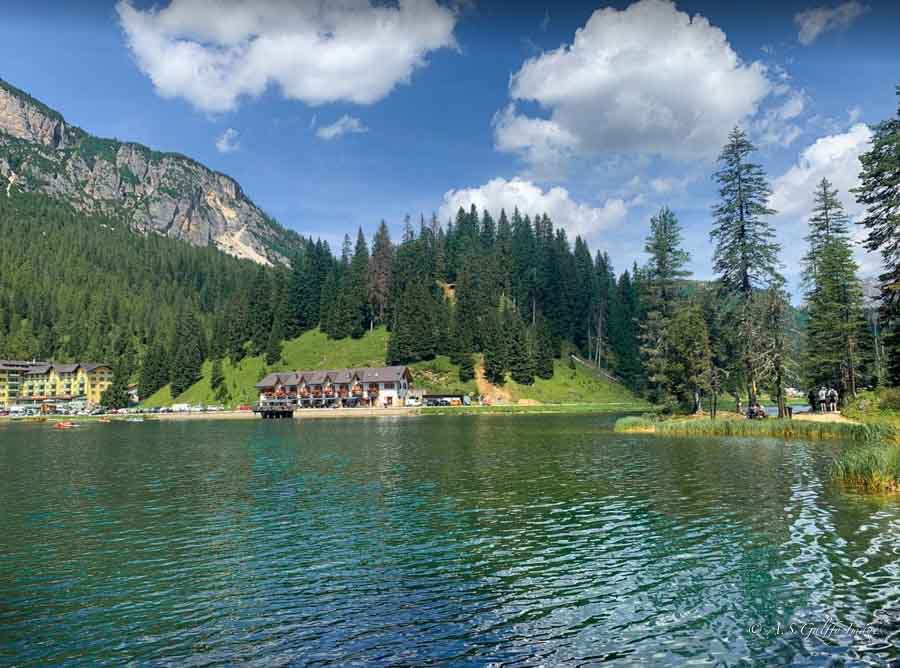
How Long Does the Walk Take
The lakeside route is roughly 2.5 to 3 kilometers and can usually be done in under an hour. That makes it a good option for anyone who wants a quick scenic outing rather than a true half-day hike. It is especially nice if you are traveling with people who are not in the mood for a long climb but still want to experience the Dolomites on foot. The terrain is gentle, the route is easy to follow, and there is very little pressure to “perform” as a hiker.
How to Reach the Trailhead
The trailhead is around the lake itself, so it is one of the easiest places to access. Parking is generally simpler than at the most famous trailheads, though summer mornings are still better than late arrivals. If you want a quiet experience, go early. The light is better, the lake is more reflective, and the atmosphere is far more relaxed.
This is not the most dramatic hike in the Dolomites, but it may be one of the most pleasant if what you want is a low-stress mountain walk. It is also a good choice on a day when weather is uncertain and you want something that does not require a huge time commitment. Sometimes the smartest hike is the one that leaves you feeling refreshed instead of tired.
Pros
- Very gentle walk with pretty views and minimal logistical stress.
- Easy to fit into a half day or combine with Tre Cime or other nearby spots.
- Good option for anyone needing a “rest” day but still wanting to be outside.
Cons
- Less dramatic than the headline hikes; come for calm, not adrenaline.
- Can feel busy near restaurants or hotels around the lake at mid‑day.
- Short enough that very active hikers may find it underwhelming on its own.
6. Val Falcina Nature Trail
At a Glance
- Distance: ~4–4.5 km loop
- Elevation gain: Moderate but manageable (varies slightly by variant)
- Time: About 1.5–2 hours
- Difficulty: Easy–Moderate (some ascent but non‑technical)
- Trail type: Loop
- Starting point: Val Falcina trailhead car park
- Access: By car; generally less crowded than major hotspots
- Best months: Late spring to early autumn (check local conditions)
Val Falcina is less famous than Tre Cime or Braies, but that is exactly part of its appeal. It feels quieter, greener, and more local, which makes it a nice alternative if you want easy hiking without fighting crowds the entire time. The trail is known for waterfalls, forest scenery, and a generally peaceful atmosphere that still feels very much like the Dolomites.
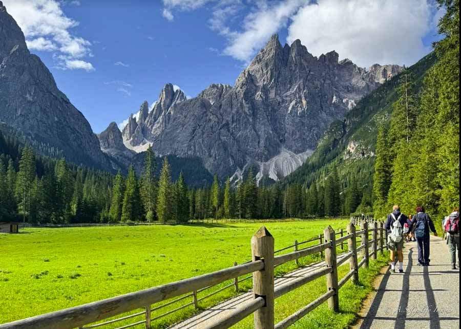
Val Falcina is especially appealing if you’re feeling a bit saturated by crowds at the classic spots and want something that feels more relaxed and local.
How Long Does the Walk Take
The route is a loop of about 4 to 4.5 kilometers, and it typically takes around 1.5 to 2 hours depending on your pace and how often you stop. The trail has some moderate ascent, but it remains very approachable. This is one of those hikes where the journey feels just as important as the destination, because the path itself is so pleasant and the scenery changes often enough to keep it interesting.
How to Reach the Trailhead
The trailhead is straightforward, and because it is less of a blockbuster destination than the famous lakes and loops, parking pressure is usually a bit more manageable. Even so, early arrival is still the best strategy in summer. The earlier you go, the more likely you are to enjoy the trail in peace, with better light and fewer people around the most photogenic spots.
Val Falcina is a good choice if you want something beautiful but not overwhelming. It does not have the instant global recognition of Tre Cime or Lago di Braies, but it gives you a quieter, more relaxed mountain experience. For many travelers, that makes it even better.
Best Time to Visit
For almost all of these hikes, the best time of day is early morning. That is when the mountains look their best and the crowds are least annoying. The light is softer, the temperatures are better for walking, and parking is much less stressful. In the Dolomites, starting early is not just a photography tip; it is a sanity tip.
If you go later in the day, you may still get nice light, especially in the late afternoon, but you will often have to deal with more traffic, more people, and more competition for parking. In places like Tre Cime and Lago di Braies, that can make a huge difference in how enjoyable the day feels. The hike itself may be easy, but the logistics can quickly become the hardest part if you arrive too late.
Pros
- Quieter and more peaceful than the headline Dolomites hikes.
- Forest, water and changing scenery make it an enjoyable, varied walk.
- Good “reset” hike between busy days at Tre Cime or Braies.
Cons
- Views are more intimate than dramatic; don’t expect towering rock walls.
- Fewer facilities compared to major hubs (fewer rifugi and services).
- Trail conditions can be muddier or more affected by recent weather.
What to Consider When Planning Your Hikes in the Dolomites
This is where a lot of first-time visitors get caught out. Keep in mind that the best and most popular hikes in the Dolomites are also the ones most likely to require planning. Tre Cime is the big one to watch, because the road to Rifugio Auronzo is controlled and parking can be limited or require advance booking depending on the season and current rules. Lago di Braies has also used parking and access controls during peak months, so it is not a place to assume you can improvise.
For less famous hikes like Lago di Misurina or Val Falcina, parking is generally simpler, but “simpler” does not mean unlimited. Summer in the Dolomites is busy, and even smaller trailheads can fill up early. If you want to avoid stress, treat early morning as your default strategy everywhere.
The safest approach is to research parking before the day of the hike, arrive earlier than you think you need to, and build in a little extra time. That way the day feels like a scenic outing instead of a logistical scramble.
Where to Stay When Hiking the Italian Dolomites
For the routes above, the best single base is usually Cortina d’Ampezzo or the surrounding Misurina/Auronzo area. These two places give you the easiest access to Cinque Torri, Tre Cime di Lavaredo, and Misurina, and it still works reasonably well for day trips toward the other spots.
Best Bases by Hike
• Cortina d’Ampezzo: Best all-around base if you want comfort, restaurants, and easy access to Cinque Torri plus Tre Cime day trips.
• Misurina: Best if Tre Cime di Lavaredo is a top priority, since you can stay very close to the trail area and the lake.
• Ortisei / Selva / Santa Cristina in Val Gardena: Best for Seceda, with strong lift access and excellent hiking-town infrastructure.
• Braies / Prags / nearby villages: Best if Lago di Braies is important and you want an early start to avoid crowds.
• Alta Badia / Corvara / La Villa: A good flexible base if you want beautiful scenery and a more central setup for moving around the Dolomites.
Best Strategy
Because these sights are spread out, it often makes sense to split your trip into two bases rather than trying to see everything from one town. A practical combination is:
- Cortina d’Ampezzo or Misurina for Tre Cime, Cinque Torri, Lago di Misurina and even day trips toward Braies.
- Ortisei or Selva for Seceda and other Val Gardena hikes.
That setup cuts down on driving, makes sunrise or early‑morning starts more realistic and helps you avoid burning energy on long transfers rather than on the trails.
Frequently Asked Questions About Hiking in the Dolomites
The hikes in this guide are non‑technical day trails chosen for regular travellers who enjoy walking but don’t necessarily train for mountain races. If you can comfortably walk several hours on uneven ground at home and you’re willing to pace yourself and take breaks, you should be able to manage most of them. Just remember that altitude, sun and changing weather can make things feel harder, so give yourself extra time rather than racing the clock.
No. All of the routes described here are standard hiking trails and do not require via ferrata gear such as harnesses, helmets or lanyards. You may read about cables or ladders in other guides covering more technical routes, but those are different itineraries. For the hikes in this article, good footwear, layered clothing and basic mountain awareness are enough.
In a typical year, the main hiking season in the Dolomites runs from late June to late September, when most cable cars and mountain huts are open and the higher trails are free of snow. July and August offer long days but also the biggest crowds and highest prices. If you prefer cooler temperatures and fewer people, late June or early September can be ideal, as long as you double‑check lift and hut closing dates before you plan.
Some of the best hikes in the Dolomites—especially Tre Cime, Cinque Torri and Seceda—are reachable by a combination of buses and lifts from bases like Cortina d’Ampezzo, Dobbiaco and Ortisei during the main season. However, having a car makes sunrise or very early starts easier and gives you more flexibility to adjust plans based on weather. In each hike section above, I’ve noted whether the trailhead works well with public transport or is more convenient with your own vehicle.
 Tre Cime di Lavaredo Hike: A Complete Guide to the Big Loop in the Dolomites