
Some links in this post earn me a small commission, at no extra cost to you.
If you were to do just one hike in Patagonia, it should be the one to Laguna de Los Tres, at the base of Mt. Fitz Roy. This iconic trek which is every hiker’s dream and one of the world’s most amazing destinations. The hike will take you to the base of the majestic mountain complex – the Fitz Roy – which consists of three peaks: Cerro Fitzroy (3,405m), Cerro Torre (3,128m), and Poincenot (2,558m). Hence the name of the lagoon at its foot – Laguna de Los Tres (which in Spanish means the Lake of the Three).
People compare the hike to Laguna de Los Tres with the famous and equally impressive trek to Torres del Paine, in Chile, and they are right. Both granite peaks are very similar in shape and both hikes are really amazing. However, the hike to the base of the Fitz Roy massif enjoys a much more spectacular scenery. It is also much more difficult than most other hikes in Torres del Paine.

We made two attempts to complete the Fitz Roy trek to Laguna de Los Tres and when we finally reached the top we just couldn’t believe our eyes!
How did Mt Fitz Roy get its name
Mt Fitz Roy was originally called El Chaltén, which in Tehuelche dialect means “smoking mountain”. The Tehuelche (South American Indians) thought the mountain looked like a smoking volcano. This is due to a rare eolian phenomenon that makes the clouds surrounding the granite peak appear as smoke is coming out of the mountain.

In 1877, Francisco P. Moreno, an Argentinian explorer, wanted to embark on a major expedition to Patagonia. He knew the British had chartered much of this territory back in the 1830s, so he asked them for a map.
The Brits agreed to give him the map on one condition. He was to name the highest peak he will discover in Patagonia after Robert Fitz Roy, the captain of the HMS Beagle, who led Charles Darwin’s famous expedition to Tierra del Fuego. And that’s how Cerro Chaltén became Cerro Fitz Roy.
Hiking to Laguna de Los Tres
Distance: 17.5 miles (28km)
Time: 9-10 hours (before breaks and photography stops)
Difficulty: Difficult

NOTE: You can hike to Laguna de Los Tres and the base of Mt FitzRoy either starting from El Chaltén (via Laguna Capri), or starting at Hosteria El Pilar (via Mirador Piedras Blancas). The trail from El Pilar is actually shorter, but it requires a car since it’s 15 kilometers away from El Chaltén.

The trail goes along Rio Blanco then climbs up through a beautiful Beech forest, passing Mirador Piedras Blancas and then getting to Camp Poincenot. From Poincenot the trail merges with the one coming from El Chaltén and goes up to Laguna de Los Tres.

Points of Interest Along the Hike to Laguna de Los Tres
We started our hike at Hosteria El Pilar. Initially, the trail follows the rocky river bed of Rio Blanco, winding through some beautiful calafate bushes.
After about 1/2 km it passes through a gate that marks the entrance to the Los Glaciares National Park. From this point on the hike goes constantly uphill, passing through a dense forest and crossing small streams.

The first 10 km of the hike are not particularly difficult, so if you don’t have the energy to do the entire Fitz Roy trek, you can stop along the way at a couple of points and turn back. This trek is extremely picturesque, so doing just part of it won’t make you feel like you wasted your time.
• Mirador Piedras Blancas
The first point where you can choose to stop is at Mirador Piedras Blancas, which offers a fantastic view of the Piedras Blancas Glacier across the valley. Most people starting on this trail actually come only to this point (8 km away from Hosteria El Pilar).

Once you reach the Mirador, you can continue to Campamento Poincenoit and Laguna de Los Tres. Or you can choose to turn back to El Pilar, which was what we did on our first attempt to reach the mighty Mt Fitz Roy.
Our initial plan was to go all they way up, but the weather began to change so we decided to turn back and try again the following day. Hiking the Fitz Roy trek in bad weather is quite dangerous, even if you are an experienced hiker. Besides, there is no point if attempting this difficult ascent if you can’t enjoy the beautiful scenery.
• Campamento Poincenot
From Mirador Piedras Blancas the trail continues through the woods for another 2.5 km, after which it emerges into a large grassland area with awesome views of Fitz Roy massif.
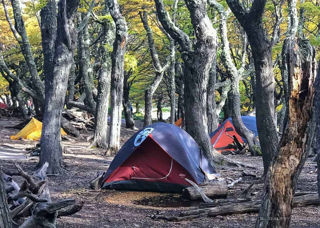
Just a short walk from this beautiful, flat area, you arrive at Campamento Poincenot, a small campground in the forest. This is the second point where you can choose to call it a day and turn back. From Poincenot you can either return to El Pilar, or you can take the road towards El Chaltén and pass by Laguna Capri.

Camp Poincenot is the starting point for one of the world’s most challenging ascents: Mount Fitzroy. Many hikers choose to split the FitzRoy trek into two days with an overnight stay at Campamento Poincenot, since the most difficult part of this trek starts right after you pass the campsite.
We chose not to stop and spend the night at the camp. Although we were really tired after 4 hours of intense hiking, the perspective of facing the dreadful Patagonian winds in a small, flimsy tent didn’t seem too appealing.
• The last stretch to the top
Up until this point, the change in elevation is not so dramatic. But as soon as you cross the Río Blanco, the landscape changes completely. There are only 2 kilometers left to go, but 400 meters to ascend! This is the equivalent of climbing approximately 1,300 feet in 1.3 miles. It is really steep! The final hurdle to overcome, before reaching the cobalt blue waters of the Laguna de Los Tres and the three granite peaks behind it.

The last hour of the hike is almost straight up, more like a rock climbing than a hike. Without trekking poles, this stretch of the trek is really difficult to do.
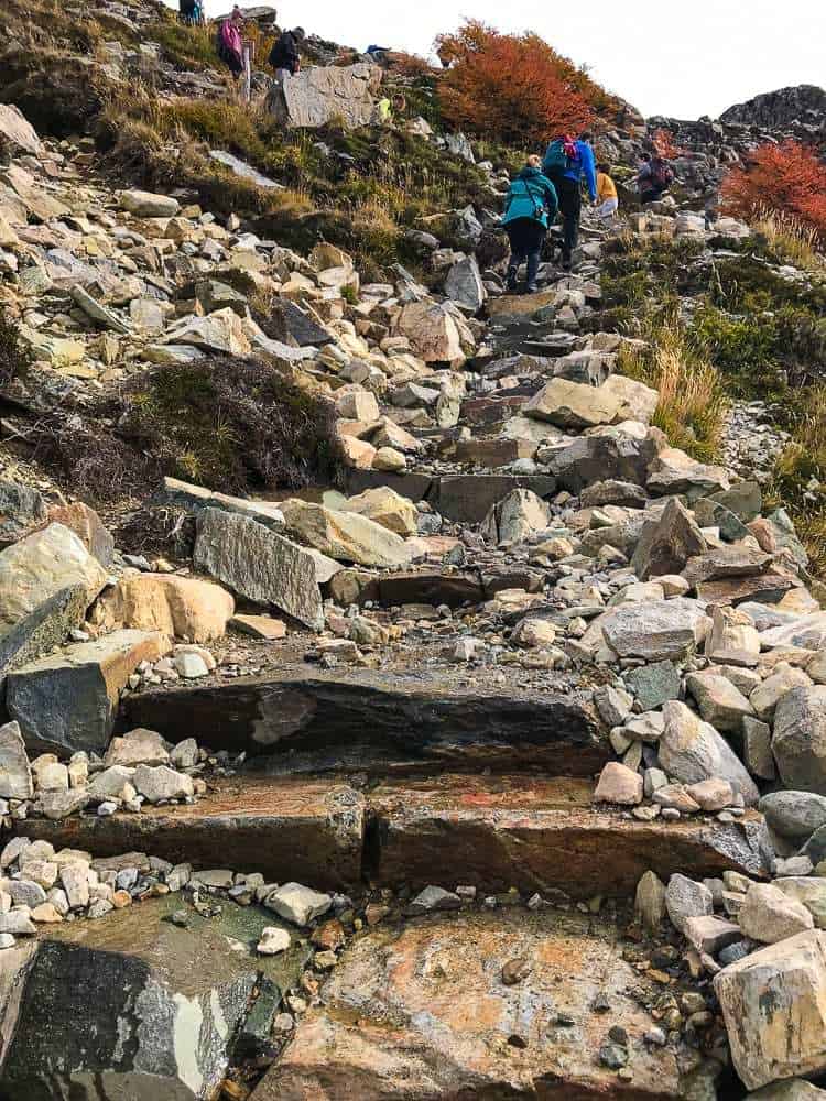
At the top of the steepest section of trail we came across a false summit. That feels a little demoralizing. Just when you think you’ve made it to the top, you realize you still have some hiking to do. But from from that point on the slope becomes a little more relaxed.

The final ascent takes you onto a moraine overlooking the Laguna de Los Tres, with the glaciers, snowfields and the three granite peaks behind it. Once you reach the top and see that view, all your efforts seem justified and worthwhile.
Words can’t express the feeling you get when you realize that you finally made it! You are now face to face with the mighty Fitz Roy peak and the blue waters of Laguna de Los Tres!
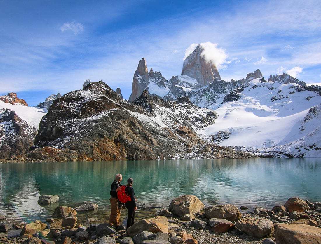
It’s so beautiful, that you don’t want to go back. But you cannot stay on the summit forever, so eventually you have to come down again!
Hiking Back to El Chalten from Laguna de Los Tres
Our way down was harder than we thought. Despite relaxing at the top for almost two hours, we felt pretty tired. Scrambling back the same rocky path didn’t seem much easier on the way down.
The stream of water that was flowing down the trail was making some boulders quite slippery. And to make things worse, just a few turns from the top, we came a cross a gruesome accident.
One of the hikers we saw earlier on the trail, an older guy, just had a heart attack. People were gathered around trying to resuscitate him, but to no avail. In just a few short minutes he passed away. Witnessing this terrible scene was a sad reminder of how fragile life can be. Hikes like these are not a joke!

Is the hike to Laguna de Los Tres worth the effort?
Most of us embarking on long and difficult hikes seek challenge. We try to push ourselves into a new body, or a new state of mind. But sometimes, when the effort is too big, even though you succeeded it feels unnerving.
More often than not, after starting a difficult hike I begin wondering whether it was a good idea. A loud voice inside my head keeps screaming at me: “this was a terrible mistake, you shouldn’t have started this… walking uphill sucks!”
Truth is that strenuous hikes are not fun, but when you manage to get to the top of the mountain you feel that your efforts were worth it. And that’s when you realize that good things always come from being able to push through the difficult parts. So although very difficult, the hike to Laguna de Los Tres at the base of Mt. Fitz Roy is totally worth it.
What to pack for this hike
The packing list for the hike to Laguna de Los Tres is pretty similar to the one I wrote about packing for Patagonia. Be sure to check that out if you are planning to visit El Chaltén and the Argentinian side of Patagonia.
The only thing I could add is that Los Glaciares National Park has a NO FIRE policy. So if you are planning to camp in the park, be advised that no cooking over an open flame is allowed.
However, there are plenty of places in El Chaltén that sell delicious food packages, with sandwiches and baked goods. These pre-made sandwiches are a good idea even if do the Fitz Roy trek as a day trip. Just make sure you don’t load your backpack too much. The last stretch of the hike is a killer!
Liked this post? Pin it for later

YOU MAY ALSO LIKE:
anda
Enjoyed this guide?

Get my new travel guides and stories in your inbox. No spam, and you can unsubscribe anytime.


Awesome post! The Fitz Roy trek looks absolutely stunning, and your detailed guide to hiking Laguna de los Tres is so helpful. The tips on timing and gear are perfect for first-timers. Any advice on how to handle the challenging sections of the trail, especially in unpredictable weather?
My only advice is to turn back if unexpected wind or rain come while you are hiking.
How absolutely awesome and detailed !! Thanks so much ! I am planning to do the hike in late Apr/early May (autumn, I believe there).. can’t wait !
You are going to love it, Norman. Good like with your Patagonia trip.
When did you hike up to Fitz Roy? I’m planning a trip in early May and am wondering if I should postpone it until the spring time. Thanks!
We did it in fall. If you can do it in fall, I would strongly recommend you do so because of the amazing red/orange color that you’ll have all around. In summer or spring everything there will be very little color around. Just greet.
What a spectacular sight! Worth every minute of the hike, I am sure. Sorry to learn about the mishap you had to experience on your descent. I fully agree that we, humans, are probably not as strong as we portray ourselves.
I’ve seen Laguna de Los Tres in so many instagram photos, but never really knew how to get there or what type of hike it took. Those post was so thorough! I can’t believe how steep that final stretch is. I’d probably have to train for something like this!
Not really. The hike is very difficult only in the last part. Most of the trail is OK, but the problem is that at the you end you are very tired.
Quite brave of you to venture out on such an adventurous hike. I have done much shorter hikes. But your pictures prove the trek up Fitz Roy is worth it! Agree with you that good things always come from being able to push through the difficult parts.
Wow, this looks like a challenging hike, but well worth the views of Mt. Fitz Roy at the end! All of your photos are beautiful and I love the fall colors along the way. Thanks for sharing about the realities of what to expect. So sad to hear about the hiker who passed away. What a scary thing to witness.
I so admire your strength and gumption. I’m planning a milder multi-day hike in Japan and need to start training. My step-kids tackled Patagonia last winter. Even though you had to turn back one day returning the next was well rewarded. Beautiful pictures!!
Thanks Elaine. We wanted to do this hike before we are too old, hahaha!
It seems that so many people are talking about Patagonia this year. I can see why climbing Mt Fitz Roy is the thing to do. But I will only ever be able to see if from afar. But seeing the “smoking volcano” from afar looks like an amazing view. So many great viewpoints on the hike. Simply stunning.
Patagonia is unbelievably beautiful. Definitely worth visiting even if you are not a hiker.
First of all, I am sorry to hear you witnessed another hiking facing his last breath, how terrible, but yet another example of how precious and short life can be. Your pictures are absolutely outstanding, it is definitely one of the most breathtaking places in the world and there is a big effort to get there. You guys were troopers and toughed it out instead of tenting – wow! What an accomplishment Congratulations. I am kicking myself we never made it that far into Patagonia – so another reason to go back.
Thanks Dorene. We truly wanted to do Patagonia before we are too old to hike in such harsh conditions. You definitely should go visit it.
Whoa this is a major trek. I have never embarked on something like this and not sure I could, but wow what an adventure. It really sad to hear about the man who had a heart attack. How scary.
It was kind of difficult to be honest with you, but we made it. I don’t think I would go back though, lol!
I love this post. OMG it’s so beautiful there. I am with you about hiking out vs camping in the blistering winds. Even in a 4 season tent it’s hard to sleep with the wind buffeting it around all night.
I never really liked camping, but when I was younger I could put up much easier with the inconveniences and the lack of comfort. However, considering the difficulty of this trek, I believe a good night sleep in the comfort of a warm room is essential.
Well I have only discovered hiking in the last five years. This hike sounds so very worthwhile. One day I will visit Patagonia and remember this. I pinned it for later as well. Thanks.
Great information Anda as we are heading that way tomorrow and thinking of doing the first part of the trek only.
The first part is beautiful Jane, but the second one is really exciting. Good luck.
I can’t wait to visit Patagonia one day to see exactly the kind of scenery you show here. The Fitz Roy trek sounds really rewarding and I think I’d be in heaven walking around with those views. Phenomenal!
What beautiful scenery! It always seems to me that good scenery makes a hike less grueling. Very inspirational, as well, for those of us who haven’t kept hiking as often as we should. #TheWeeklyPostcard
Oh, I started to read the hike details and it´s already Argentinian Patagonia! I don´t see the border between two countries in this area though(on google maps)! Do you get to Los Glaciares National Park from Chile of from Argentina only?
You can get there both from El Calafate, which is in Argentina, or from Chile.
What a hike! 9-10 h must be quite a climb, but the views are so worth it! The Fitz Roy trek definitely goes to my travel bucket list! And your photos from Chile keep giving me some serious wanderlust a 3rd weekend in row.
Patagonia is on my bucket list for a while now, Anda! Reading your post made me realize that hiking up the Laguna de Los Tres should be on the top of my list. Is it a challenging hike?
What incredible scenery – and beautiful photos. I’m pretty sure I couldn’t complete this hike but what rewards to you for making it. This also reminds me that I haven’t been hiking in quite some time 🙂
You shouldn’t abandon the good, old habit of hiking, Jill. It keeps in in form.
Wow, it does look like a stunning hike, great pictures! As I was reading about that last steep part I was wondering if you had to go back down the same way. I think going done that steep part would be the hardest for me. I would have to take it very slow. Also sad to read about that other hiker, life is just so precious.
Coming down was hard for me too, Anisa. Especially after hiking for 6-7 hours.
It’s like each post from your trip to Chile is even more ridiculously beautiful than the last! It would be a dream to hike this and maybe one day we’ll be fit enough to attempt it! Just wondering why though you attempted to hike it twice?
Because the weather turned bad and we didn’t want to take any changes. Hiking the top part of the mountain when the winds are blowing hard, it’s quite dangerous Besides, you want to go up there and admire the landscape, not just make the effort and stay in the rain.
The photos of the scenery are absolutely stunning. I agree with you in that I’d rather do it all in one day as opposed to spending a cold night in a tent (and having to cart the tent and extra gear with me). Your “descent into chaos” is a reminder that anything can happen at any time.
Yea, that was quite a sad event.
This looks like such a grueling hike but those views are incredible. Definitely worth the struggle and so happy for you with this accomplishment. I remember you posting about that man who passed away. What a tragedy. The scenery looks like postcard shots.
Glad you liked the pictures, Mary.